We need another song, and quickly

Saturday brought a chance of afternoon thunderstorms and “hazardous weather,” and an even greater chance of hazardous ferry and cargo ship traffic.  We figured it best to take it all head-on so we left early.  It was hard to tell how early, of course, because the sun never really came up.  Just cold and cloudy all day.

Yup, ferries lugging tourists to and from Mackinac Island.  Absolutely none of them cared about the huge wakes they toss off.

The cargo ships like John G. Munson—who caused us to pull over to let her pass—also didn’t much care if they bothered us.

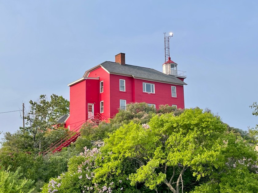
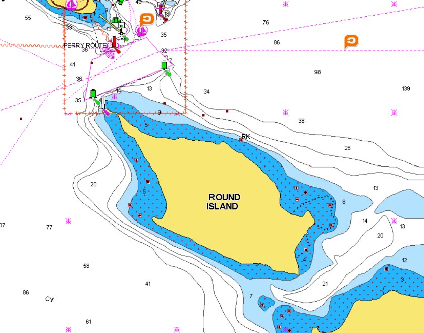
That lighthouse, by the way, is the Round Island Light.  Except it’s on the tippy-end of a point on an island that really should be called Genie Lamp Island or something, because it ain’t close to round.

Once the traffic cleared, we settled in to a nice smooth cold ride under weirdly-colored clouds.  Intermittent sprinkles and not a smidge of sun.  It’s worth a photo though, because it put us back on Lake Huron.

Then on in to DeTour Village, which Father James Marquette named in disgust when road construction forced him to deviate from the path he was taking down to the heathens he needed to convert in St. Ignace.  We assume the good Father and his band of Jesuit priests didn’t stay long, because the village has two marijuana shops but not much else.

Back on Tumbleweed, we watched a few episodes of Good Karma Hospital after the rain stopped.  Will Dr. Varma stick with Ruby?  Or will he run off with that skeezy plastic surgeon from Mumbai?

Adding to her expanding portfolio of wildlife photos, Dana bagged her first mink.  She didn’t have her big camera with her but he’s still cute.

After the medical shenanigans in Barco, but before lights out, Ocean Voyager passed by.  We assume none of the passengers needed weed since it didn’t stop.  Neither Ocean Voyager nor her sister ship Ocean Navigator leave the Great Lakes—raising obvious questions for whatever fraudster suggested the “Ocean” part—but it was cool to watch them on their way to Mackinac Island nonetheless.

Up early yesterday, with the wind pinning us to the dock.  The next couple of days looked decidedly rotten, however, so we peeled away and took off.  Turned out to be a good call.  50° all day, but the wind died and the St. Marys River was acceptably calm.

Hey wait!  It’s the Round Island Light again.

This one, at least, makes sense.

Halfway to Sault Ste. Marie, we started seeing Muskoka chairs instead of Adirondack chairs, reminding us that the shoreline off the starboard side is Canada.

Yup, there’s the Maple Leaf and smiling cottagers.  It’s Canada all right.

The St. Marys River is a frigid 54°, which means nobody needs to waste money on a wall to keep out the illegals.  A big and beautiful wall that blocks all the Canadian smoke, however, would be quite useful right about now.

The Canadians who own this impressive home probably don’t need to sneak across the border, because, as Dana shrewdly noted, “If they’re rich enough to afford that house, they’re rich enough to leave in the winter.”

One last cool thing from the trip up.  This is a scenic enough chapel, but it’s also the Sailors Encampment Channel East Range Front Beacon.  The marketing company that came up with that range light name must’ve been paid by the letter.

When we pulled out of DeTour yesterday, our AIS showed the cargo ship Hon. James L. Oberstar steaming up about fifteen miles behind us.  James Oberstar was a longtime congressman from Minnesota who undoubtedly appreciated the honor when they renamed the ship in 2010.  But what about the other guy?  We found no online information about how the family of one Charles M. Beeghly felt when his name was painted over.  Oberstar desperately tried to catch us in one of the several passages that would’ve been too narrow for comfort—and steadily closed the gap—but the section of river with a speed limit foiled the plan and we were able to tie off on the George Kemp Downtown Marina fuel dock just as she got close.  Ha.  So long, suckers.

So obviously we made it to Sault Ste. Marie, which we referenced briefly that time we smuggled our two dogs both ways across the border:  Sault Sioux Sue Soo.  Except that was Sault Ste. Marie, Ontario, not Michigan.  In a shocking twist that nobody could have seen coming, both Sault Ste. Maries were named by—wait for it—Father Marquette!   The name is French for “Rapids of Saint Mary,” with the local Chippewa tribe later incorporating the “Sault” part.  Some treaty along the way gave those same Chippewas permanent fishing rights in the rapids, which is why—according to the menu—they supplied the delicious whitefish that the restaurant prepared Cajun style for Dana and lemon peppered for Doug.

Anyway, Sault Ste. Marie turns out to be a charming place with lots of interesting stuff to see and a cutesy tourist section downtown.

This is the John Johnston House, built in 1796, making it “The second oldest building in the northwest,” according to the plaque.

Wait just a second here!  Does it really say “Northwest?”  WTF?  We get that in 1796 not even the Dutton family had ventured much past the Mississippi River, such that the cartography of the day put Sault Ste. Marie in the upper left corner of the civilized world.  But that plaque is dated 1941.  By 1870 there was a railroad connecting the east coast to San Francisco.  In 1941, we had a massive naval fleet in Hawaii, at least up until December.  Washington and Oregon had been states for over seventy years.  The point is that Michigan is in neither the “northwest” nor the “west,” no matter what the plaque or the University of Michigan’s dumb fight song says.

Between 1822 and 1893, Fort Brady sat along the river to protect the Yoop from invading British and Canadian forces hellbent on putting Queen Elizabeth on our currency.  All that’s left of the fort now is a reconstructed portion of the palisade and a sign warning the soldiers not to bring either guns or pets.

It’s easy to picture this section of fence in a Mel Brooks movie—with all of the combatants climbing over it rather than going around the sides—although he used a similar gag in the Blazing Saddles tollbooth scene: “Somebody’s gotta go back and get a shitload of dimes.”

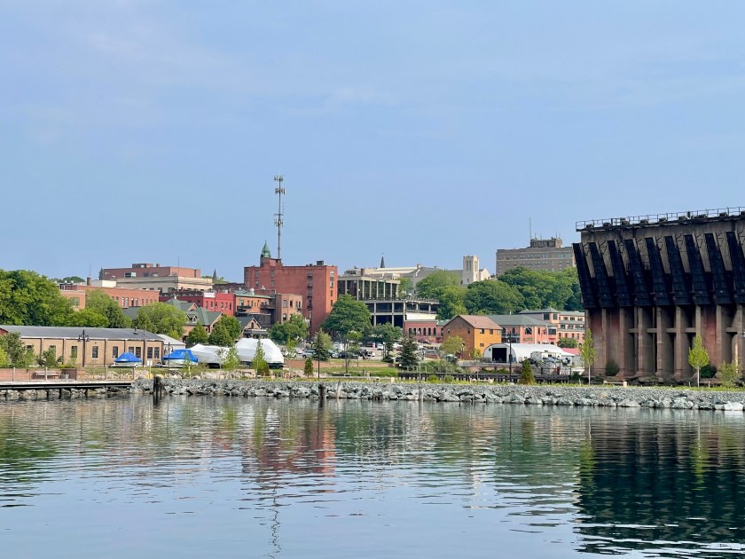
This is the “Tower of History.”  With a nod to Soviet-era brutalist architecture, Sault Ste. Marie built it as an observation platform so that tourists can observe Tumbleweed transit one of the famed Soo locks tomorrow morning.

That’s right.  Tomorrow we pop out into Whitefish Bay.  Which brings us equal parts nervous excitement and profound sadness.  Excitement because it’ll be our first time on Lake Superior and will put us that much closer to seeing Tom and Deb on the Keweenaw Peninsula.  Sadness because in the time since we started all of this in 2017, we’ve carelessly wasted just about every interesting tidbit and useable line from The Wreck of the Edmund Fitzgerald.  Grrrrr.

Rain has prevented any further exploration, but we did meet our neighbors Doug and Beth on Boomerang, a pretty blue Nordic Tug that seemingly escaped The Great Lake Michigan Midge Plague of ’23.  They’re Lake Superior veterans, so the plan is to follow them on a marathon voyage all the way to Grand Marais, skipping the dangerously shoaled Whitefish Point.  An unfamiliar commercial lock followed by eleven hours on big water isn’t at all appealing but it’s better than the alternative.

Ha. We found some unused lyrics after all

Before anyone is frightened off by the length of this lengthy post, don’t worry.  It’s mostly photos.  Just don’t apply that formula equating each picture to a thousand words and it’ll be fine.

Back to Sault Ste. Marie.  We didn’t leave as planned.  Experience informs us that doing locks in rain is unpleasant, and it’s not hard to extrapolate that it’d be even less pleasant if the rain is coming down when it’s 46°.  That’s what we faced when we awoke Tuesday morning.  Yuck.

Plus, a Small Craft Advisory was in effect in the zone on the other side of Grand Marais and it seemed possible—if not likely—that at least some of that danger might slop over into the zone we’d spend hours crossing to get there.   Eleven hours of crap seemed like a poor way to celebrate Dana’s birthday, so we stayed put.

Unfortunately, as we’ve also learned, cold and rain don’t mix well with exploration or outside boat chores.  But we did mange a bit of both.  From Tumbleweed’s deck we could see Valley Camp, a former steam-propelled laker turned museum.

As the big freighters go she’s smaller than most, but the museum part was fabulous.  Long-time followers will recall the photo of the bullet-ridden Maersk Alabama lifeboat that Captain Phillips—the real Captain Phillips not Forrest Gump—was in when Navy SEALS sniped the woefully ignorant Somali pirates.  That was a cool lifeboat.  This one is just as cool.  It’s from Edmund Fitzgerald, and washed ashore the day after the sinking.

Lots of other stuff, and basically every corner of the ship was open for inspection.  Very worthwhile.  From Valley Camp’s wet bridge deck we could see Tumbleweed.

Dana found some shops, and Doug fashioned a decidedly inelegant but more stable support for the Starlink dishy.  Maybe not the best birthday, but a lot better than meeting a storm.

Wednesday looked to be a decent day to travel, although the sun that peeked out as we left the marina at 6:15 disappeared quickly.  The lock dudes took us straight into the lock.  Easy peasy.

Although they sent us through the smaller MacArthur Lock, the adjacent lock demands mention.  Poe Reef and Poe Lighthouse are one thing, but Poe Lock?  Who named it “Poe Lock?”  Archie Bunker?*

Twelve miles of comforting St. Marys River shoreline later, we dumped out into Whitefish Bay.  Lake Superior.  The largest lake in the world by surface area.**  Superior holds 10% of the earth’s fresh water, along with what we guess probably is the world’s largest supply of delicious whitefish.  Last December, the lake dropped two inches — which equaled 1.1 trillion gallons.  To put that into Arizona perspective, a foot of Lake Superior water poured into Lake Powell would dang near put it over the top of Glen Canyon Dam.  Damn.

We know, we know.  Lake Superior looks just like Lake Huron, and Lake Erie, and Lake Ontario.  Which makes sense, of course, since the water up here is on its way down the St. Lawrence Seaway, past where we fought biting flies with Second Wave after finally leaving Oswego, past where we met No Drama in Quebec City, past where we watched Laughter sink in Sainte-Madeleine-de-la-Rivière-Madeleine, and out to the Atlantic Ocean.  But yet we still take the pictures.

Months ago we dropped a chart pin directly above the Fitzgerald wreckage, thinking maybe we’d pop over for a photo shoot.  Um, not a chance.  We rounded Whitefish Point and made a beeline for Grand Marais.

But the Mighty Fitz is fifteen miles straight out there, under 530 feet of frigid water and a blanket of light fog.

We know how far she’s out because “the searchers all say they’d have made Whitefish Bay if they’d put fifteen more miles behind her.”  Plus we could measure it on our charts.  It bears noting, however, that if Captain McSorley had patiently waited for smooth water like we did, things might’ve turned out differently for those 29 souls who never surfaced.***

Then the fog got foggier and mostly stuck with us for the five hours into Grand Marais, lifting only briefly to reveal the Crisp Point Light.  Now it’s just an historical site, completely worthless to us.  And not even very pretty.

There’s nothing wrong with fog at night while we’re sleeping between flannel sheets under mounds of blankets, of course, but any other time cold, clammy, can’t-see-a-damn-thing fog is a pain.  Yet there it was again in West Bay on Thursday, although not nearly as thick.

Thursday also brought another Small Craft Advisory.  Five hours to Munising in this crap?  Fog-et about it.  We’ll ride it out with shore power, Starlink, and the heaters blasting.

Fortunately the drizzle and fog faded just in time for a four-mile hike to see Sable Falls and Sable Dunes.  The only sad part was that by the time we got back to the trailhead the bear in the parking lot was gone, so no pictures of him or her.

Friday morning the sun sort of was out, but then more unpredicted fog descended, but then the sun came back out for good.  Hey now!  Things are looking up.

Here’s the thing.  When the sun is out, Grand Marais is dang appealing.  The former logging and shipping center now is a summer vacation destination for Yoopers.

The neatest of the historical buildings is The Pickle Barrel House, built by a syndicated Chicago Tribune cartoonist whose Teenie Weenies apparently lived in a much smaller one.

The best thing about being fog-stuck for a couple of extra days in Grand Marias, however, was that we unexpectedly caught the annual Seaplane Pilots Association “Splash-In.”  Now that was awesome.

In addition to catching seaplanes, Dana got an action shot of some dudes who don’t mind 44° water and think the whole “electrical current in marinas can kill you” thing is a myth.  Those crazy Yoopers.  Go figure.  We don’t know if they survived, because we left.

Gorgeous trip to Munising, in large part because we swerved over to follow along the Pictured Rocks National Lakeshore.

Lots of spectacular stuff along there.  Sort of like the Cabot Trail on Cape Breton, but with fewer references to Family Affair’s Mr. French.

Our friend Deb warned us about the “Fata Morgana,” an optical illusion caused by visible light bending through air layers of different temperatures.  There’s a school of thought that Titanic and her potential rescuers were fooled by this phenomenon.  We don’t know if we saw one, but what we did see was pretty odd.  The upper dark band is an island.  The lower dark band that looks like a wall isn’t real.  But we didn’t hit anything.

In addition to the bit about lifeboats, long-time followers also know of our affinity for lighthouses.  We’ve photographed a mess of ’em.  The East Channel Light (RIP) easily is top-five.  Built out of sticks in 1868 by people who obviously didn’t know the story of the Three Little Pigs, it served mariners traversing Munising Bay—sort of—until 1908.  In 1908 someone realized that the lamp was so weak that ships were smashing into rocks anyway, which explains all the glass-bottom boats running shipwreck tours around Munising.  Who cares though?   It’s super cool.

Now about Munising.  Fine little town, we guess.

They even have an art district, although technically it’s just an alley.

The municipal marina mostly serves the tour boat population.  Those boats are indestructible tanks, but they put us out with them on the industrial wall even though Tumbleweed isn’t.  This undoubtedly colored our opinion of Munising, and not in a good way.

That long dock was built for commercial shipping back in 1938, which means that the steel with uneven edges that we had to step over when unsafely getting on or off the boat has been rusting nicely for 85 years.  It wasn’t quite as dangerous as when we tied up to a barge at Logsdon Tug Service on the Illinois River, but close.  We later inflated and deployed the huge fenders we normally save for the scary locks we encounter from time to time.

Unless they fix the floating transient docks by the time we come back through, we ain’t stopping at Munising again.  To add insult, Tennessee lost to LSU in the College World Series.  Grrrr.

This morning was a warm-ish, sunny-ish, smooth-ish, easy-ish run to Marquette.  First thoughts?  Of the zillion things we’ve seen that somehow are related to the good Father Marquette, Marquette is at the top.  The marina is awesome, the staff is great, and everything we tried at our first restaurant was crazy delicious.

On the way in to Cinder Pond Marina, we passed a giant something sticking out into the water.

What’s that thing in the water?  It’s an old iron ore dock, that’s what.  We know this, because the restaurant folks fielded the question enough to put the answer on their shirts.  Dang clever, that.

Here for a week or so, then up to meet Tom and Deb and Lea on the Keweenaw Peninsula.  We’ll scout out more Marquette treasures and report them next post.  This one already pushes the page limit of decency.  Although mostly it’s photos.

——————

*“Meathead.  Dead from the neck up.”

**The largest lake by volume is in Russia, but Russia doesn’t count any more.  Russia sucks.

***“Superior, they said, never gives up her dead.”  There’s a reason for that.  The deep water is too cold for the bacteria that normally eat bodies until they create enough buoyant gas for said body to float.  True fact.  Somebody should tell the mob.  No need for concrete shoes on Lake Superior.

Now about Marquette

When we last surfaced in this blog, we barely had pulled into Marquette.   The largest town on the Yoop.  The “Queen City.”

What’s that?  Cincinnati is the “Queen City?”  So is Charlotte?  And Fargo?  Turns out there are some forty Queen Cities in these United States, including three in Alabama alone.*  But this post is about Marquette, because we’re in Marquette.

Before we left for another trip back to take care of some stuff in Arizona, we bopped around town for a couple of days.  The paths are green and cool and go through foliage that isn’t at all like Arizona.

We’re suckers for cool buildings, and despite being small for a “city,” Marquette has a mess of them.  Starting with the “World’s Largest Wooden Dome.”  We have no idea if the claim is true, but the Superior Dome—which is home to Northern Michigan University Wildcat football—is impressive.  We’d never heard of the Superior Dome before and as we approached Marquette in the haze we thought it probably was a huge sand pile, but we walked over to check it out.  We are able to confirm that indeed it’s a wooden dome.

NMU’s website says it’s fourteen stories high at its peak, covers over five acres, and required over a hundred linear miles of Douglas Fir decking.  Sadly the Superior Dome was closed, so we couldn’t go in and personally verify any of these measurements.

Marquette Harbor Light is another of those lighthouses that now is a supposedly-haunted museum.  It dates to 1866, when Marquette’s proximity to vast iron ore deposits created a boom in the shipping business.  Sadly the lighthouse was closed, so we couldn’t go in and verify that indeed there are ghosts flitting about.

Here’s St. Peter’s Cathedral.

St. Peter’s is impressive and has a bunch of history and all, but mostly we remain in awe of the Catholic tradition of fundraising.  Per the official Catechism, “The faithful . . . have the duty of providing for the material needs of the church.”  The non-faithful might quibble with using parishioners’ tithes to build an ornate cathedral that arguably isn’t a “material need,” but at least it’s pretty.  Sadly St. Peter’s was closed, so we couldn’t go in and donate.

After he was George Bailey and before he was Ranse Stoddard, Jimmy Stewart was a small-town lawyer who worked a minor miracle in Anatomy of a Murder, which was based on an actual criminal trial that unfolded at the stately Marquette County Courthouse where the movie later was filmed.  We do love a good movie site.

Next up, Old City Hall.  In the few minutes we were willing to spend on research we didn’t find anything interesting about it, but here it is.

This former customs house is one of the oldest surviving buildings on the Upper Peninsula.  A developer bought it and is turning it into a condo building.  If we were buying a condo we’d want a porch and more windows and better parking, but that’s just us.

Now, we know that not everyone is into old buildings.  Someone reasonably might say “The old buildings are okay, but what if I was short on time in Marquette and unexpectedly but urgently needed to buy a colorful ukulele?”  Yup, Marquette’s got you covered.  Sadly the store was closed, so we couldn’t go in and show off our harmonized rendition of “Tiny Bubbles.”

The park near the marina has a memorial dedicated to native son David H. McClintock, a naval officer whose submarine exploits “changed the course” of the Second World War.   Maybe that’s home-town hyperbole and maybe it isn’t, but the memorial is one of the coolest we’ve seen.

A couple of other boat-related things.  Ocean Navigator pulled in during our stay.  We last saw her alongside the wall in Sault Ste. Marie.  Ocean Navigator was interesting because (1) her itinerary doesn’t seem to include Marquette, and (2) although she never leaves the Great Lakes her stern shows Nassau as her home port.

We found the latter point rather disturbing, until we remembered that Tumbleweed’s home port is Scottsdale.

An unnamed Marinette 28 has been next to our spot at Cinder Pond, which wasn’t really all that interesting until we looked inside.  That’s a museum-quality display of spoon lures right there.

Finally, the nice couple on Blessings Flow pulled in while we were gone.  They’re just starting their Loop.  It wasn’t until we were chatting with Lance and Brenda that we realized we knew their Bayliner back when she was Baytripper.  Although we had some fun times playing cards and pickleball with Bruce and Bev, it’s not our fault we didn’t immediately recognize the boat because it no longer reeks of dead Asian carp.

So that’s Marquette.  If all goes as planned, ten hours underway tomorrow will get us to Hancock.

——————

*For obvious reasons, the Alabama tidbit brings to mind Sammy Kershaw’s classic song “Queen of My Double Wide Trailer,” which includes one of the great lines in country music: “She said he rebuilds engines and his name is Earl, he’s the Charlie Daniels of the torque-wrench.”  Poetry.  Pure poetry.

Victoria or bust

Ever since we started this cruising thing back in 2017, our friends Tom and Deb have been pushing us to meet them in Houghton-Hancock.  We’ve now spent a week here.  Check that bad boy off the master to-do list.

First, however, we had to leave Marquette.  It was cold, wet, and smoky at 6 a.m. when we got up.  It was cold, wet, and smoky at 6:45 a.m. when we pulled out of Cinder Pond and hooked around the possibly-haunted Marquette Harbor Light.

Mostly it was cold, wet, and smoky for nine hours, although brief windows of sort of sunlight broke through now and then.

According to the author of Scott Bakran’s Field Guide to the Upper Peninsula, Big Bay Point Lighthouse is a worthy attraction in these parts.  It’s now the Big Bay Point Lighthouse Bed and Breakfast.  According to the website, the inn is “A great place for adults in search of a secluded retreat from modern life” — which we figure is code for “We don’t have Wi-Fi.”  Regardless, the grounds presumably are more impressive when it’s not cold, wet, and smoky.

Without a doubt, the best lighthouse of the trip was the Keweenaw Waterway Lower Entry Light.  That’s because (1) Lake Superior was a bit lumpier than we like and the waterway promised to be smoother and (2) it meant we were less than two hours from stopping.

The Keweenaw Peninsula sticks out into Lake Superior like a witch’s crooked finger would look if she was casting an evil spell on Ontario.  The waterway bisects the finger at roughly the second knuckle, creating “Copper Island” out of the top half, so named because it was home to the country’s first copper boom.  Apparently it’s a thing to kayak or canoe around the circumference, but it takes a week or two, so na.

Anyway, we enjoyed the nice ride on up to the Houghton County Marina.  Which is on the Hancock side of the canal, across from Houghton.  Yoopers.  Go figure.

Now the following photo requires a comment.  It’s not the pretty sailboat that’s interesting here.  It’s not the rusting crane.  It’s the little hill behind them.

That’s right, that’s Mont Ripley—believe it or not—boasting “112 challenging acres of skiable terrain” and a whopping 440’ of vertical drop.   Anyone thinking of mocking Mont Ripley, of course, would do well to remember that it’s nearly twice the size of Mount Holly, which is a dirt pile/ski resort in the mitten part of Michigan. Deb grew up skiing on both of these, er, mountains, however, so that’s about all we can say without being offensive.

The marina guy told us a dockhand would be waiting on the dock for us, and sure enough from way off we could see a very enthusiastic girl waving white flags.  Now that’s a great idea.  All marinas should do that.  No more trying to spot a guy who blends in with the boats.  We’ll just head for where the helpful girl is waving us in.

Wait!  That’s Deb welcoming us to Hancock!  Never mind that we almost went in to the wrong slip.  And those aren’t white flags, those are Finland flags.  Fins to the left, Fins to the right.

The southern of the twins cities is Houghton, “Birthplace of Professional Hockey.”  Turns out the first professional hockey actually may have been played in Pennsylvania two years earlier, but up here they’ve been so proud of the claim that they should just keep the signs up.

Regardless of the whole professional hockey thing, Houghton is a nice place to live.  We know that because it’s the town motto.

Over on the Hancock side, it’s not quite so nice, at least if you want to ride your snowmobile on the sidewalk.

As an aside, we’d never want to live full-time in a place that has an ordinance banning snowmobiles on sidewalks.  Not because we think it’s a bad ordinance, but because the conditions make it physically possible to ride a snowmobile on the sidewalk.*

Hancock is famous as the home of Finlandia University.  Seriously, the name is “Finlandia University.”

This isn’t one of those fly-by-night online schools either.  Founded in 1896, Finlandia’s collection of Finnish-American stuff is the world’s largest.  Except two months ago financial mismanagement and dropping enrollment led the Board of Trustees to shutter the place for good.  The press release announcing the closure did not specify a disposal plan for the cafeteria’s large supply of lutefisk pasties.**

Thanks to our shrewd planning, we encountered no snow.  In fact, even the smoke and haze blew east, giving Deb and Tom some some gorgeous days to show us around.   Very cool towns.  Great restaurants.

“The opulent High Victorian design of the Houghton County Courthouse testifies to the prosperity that the copper boom brought to the area in the late nineteenth century,” says the sign.  It’s pretty ornate alright, but as far as we can tell no famous Jimmy Stewart movies were filmed here.

Friday evening we sat out on the Sydenhams’ awesome dock.  Deb’s family history in the area goes back multiple generations, which is why they have a very cool summer house on a lake.  That’s also why she can point to just about every building for miles around and tell a story.

Our adventure day took us on a hike and foggy beach visit over on the west side of Copper Island.

On the way back, we passed through Calumet.  Calumet is famous as the place where Deb’s mom once lived, and for the tragic deaths of striking copper miners and their families who were trampled in a stampede caused by some dude falsely shouting “fire” during a Christmas party.  Seventy-three people died.  Nobody ever officially identified the culprit, although Woody Guthrie had no qualms about fingering “copper boss’ thugs” in his not-great ballad “1913 Massacre.”  Calumet is a cool little town, although the place we stopped to get pie didn’t have pie.

Back in Hancock, we went up the hill for the Quincy Mine tour. These mines were all over the area during the copper years, but at nearly two miles the #2 Quincy mine shaft was the deepest.

What at the time was the world’s largest steam engine powered the world’s largest hoist, which allowed Mr. Quincy to make a fortune in copper while sending hundreds of poor slobs down to their death.

Regardless, the tour—much of which was slogging through a dark wet tunnel—was fabulous, despite the “Big Bad Johnlyrics playing on loop in Doug’s head.

One evening, Deb’s Uncle Ray and Auntie Claire joined us for dinner at the Mexican place and drinks on the flybridge.  Lots of drinks.  Too many drinks.  Ray summoned his buddy Skeeter to do a Coast Guard inspection for us but Skeeter preferred vodka and tonic, with lemon.  No sticker for Tumbleweed.

While enjoying Yooper wit and wisdom we watched some dude driving his car around in the water.  We couldn’t tell if the girls in the back were hitchhikers he picked up, but if so he might end up in the pokey with the scofflaws who ride snowmobiles on the sidewalks.

After some traditional Fourth of July pickleball, we popped back to Dollar Bay for the traditional small town parade.  These always are fun, although this is the first time we’ve seen Santa Claus in one of them.  Yoopers.  Go figure.

This is as far north as we’ll get this summer and as far west as we’ll get this summer.   Much more importantly, we had a great time with Tom and Deb.

So what’s with the Victoria reference?  And why are we turning around rather than exploring the Apostle Islands, Isle Royale, Duluth, and Thunder Bay?  Well—shockingly—we changed our plan.  Now we’re heading east through Ontario, down the east coast, loading Tumbleweed on the deck of a cargo ship, and then meeting her in British Columbia.  We’ll see what a few summers in the San Juans, Inside Passage, and Alaska do for us.  So we’re hustling to make Fort Lauderdale by the end of November.  That should be doable unless a hurricane sinks us, but we’ve got to pick up the pace.

——————

*Also, we’d never choose to live in a place with a snowmometer.

**Dana luckily found a shop with a few remaining “FU” shirts for sale, so Finlandia University’s name will live on aboard Tumbleweed.

So long Michigan, it’s been nice to know yoop*

This is the part of the blog where we deplete our arsenal of euphemisms for the overused “been there done that” cliché, because new places to stop along the route out of Lake Superior haven’t popped up in the last two weeks.

First up, the trip back to Marquette.  When we left Houghton-Hancock at 6:45, the predicted fog was hanging low enough to cover Mont Ripley but not so low that it impacted us.   Load up some Merle and let’s go.**  Very nice.

Not only did we encounter no fog, for all nine hours the water was so smooth that we didn’t waste the energy it would take to bend down and flip a switch to activate the stabilizers.  Extra very nice.

As we neared Marquette we snapped a shot of the Superior Dome just to prove that we’re not idiots for thinking on our first approach that it was a huge sand pile.  No?  Then try squinting like you’re looking through a filter of that sweet Canadian smoke.  Looks like a huge sand pile now, doesn’t it?

We’ve already done Marquette so there’s no use flogging that dead horse.  This time through, however, we managed to find a statue of the Old Man himself:  Father Jacques “Don’t call me James” Marquette, without whom this city probably would’ve been called something else.

We also ate for the third time at Lagniappe Cajun Creole Eatery, because it’s one of the best restaurants we’ve found.  In our lives.  Ever.  Shrimp and Grits for Dana, Shrimp Creole for Doug.  Yum.  A few errands, boat chores, a drone flight, and a good night’s sleep later, we headed back to Grand Marais.

Thanks to Dana’s unrivaled planning ability, another gorgeous trip.   Confederate Railroad and Don Williams provided the sound track.  Upon departure we were able to naked-eye the sun—such that we needed neither our compass nor our sextant to confirm that we were heading in the right direction—although the odd square shape did give us pause.

Because of, you know, the whole crappy commercial wall thing, we gave Munising a skip and went straight to Grand Marais.  The only thing of interest along the way was being passed by our old pal, the still oddly-named Hon. James L. Oberstar, five miles off to port and on her way to Dearborn.

We’ve already driven Grand Marais into the ground, so not much to add.  Topping off fuel and getting a pump-out hardly seem noteworthy.  A dude did stop by with a couple of Seaplane Splash-In shirts since the booth wasn’t open yet when we left last time, so there was that.  Oh, and there was a unicorn in West Bay, which we know is a reach but at least it’s something.

This morning—very early—a malfunction in some something or other just outside our cabin started an infernal beeping that prevented sleep, so at 4:30 we decided to just get up and start the eleven hours to Sault Ste. Marie in the dark.  The good news is that the moon was shining a bit, and up here the sky starts to lighten seemingly right after sundown—which we know from experience sucks at night almost as much as a beeping noise—so we didn’t hit anything.

Shortly before rounding Whitefish Point, we subjectively confirmed that—like so many other things—even through a telephoto lens from a mile away the Crisp Point Light appears much crisper when observed without an opaque screen of smoke and fog.  This joint doesn’t get many visitors, probably because it sits at the end of a twenty-mile-long gravel road.  

When we passed by here in the other direction a few weeks ago, we completely missed the small stretch of rural Alabama shoreline.  Who knew?

Rather than tangle with the commercial American Soo lock, we opted for our first Canadian lock of the year, which sounds like a betting tip but isn’t.   By the time we get to Rouses Point we’ll have done another seventy or so, although in Quebec they’re not locks, they’re écluses.

Speaking of the sun, there was nothing new under it in Sault Ste. Marie.  Except for the streets blocked off for Gus Macker’s Three-On-Three Basketball Tournament.  That was new.

From here, we’re zipping (at 7.5 knots) along the North Channel (the one on Lake Huron, not the one in Europe), down the Georgian Bay, to Port Severn.  Where we have a date.  With Brad and Kate.  And if we’re late, they’ll have to wait.***

——————

*Okay, we apologize.  That’s embarrassingly horrible.

**“There’s nothin’ harder on your heart than old Haggard and Jones.  They oughta put warning labels on those sad country songs.” – Doug Stone

***We also apologize for doggerel that’s even more embarrassingly horrible than the titular pun.